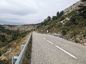
This is a photo from two years ago, i stood there for a good minute wondering how the hell and why this weird cycle path was there. It is in southern France, on the climb to Col d’Ecre, bit north of Nice.

Take a guess, i finally fully understand.

11 points

Beats me… Cycling pull-off so faster vehicles can pass?

permalink
report
reply
2 points

No, it has nothing to do with cars.

permalink
report
parent
reply
10 points
permalink
report
reply
7 points

Oh…. The posts are the sensor that snaps a picture and uploads it

permalink
report
parent
reply
3 points
*

Now that i have found this, i kinda want to go back and collect the cols, haha.

Seems like quite some people snap a pic of themselves there. Not sure if it’s the best way to spend money on cycling infrastructure, but i think it’s a fun little project, i like it.

permalink
report
parent
reply
5 points

I still have no idea what it’s for

permalink
report
parent
reply
3 points
*
SPOILER

Maybe i was exaggerating when i said i fully understand it. There is this Cols Connectes thing from the department alpes maritimes where climbing a col is being gamified, to collect the cols and take the times, upload photos. And this infra is part of it, taking a photo. Maybe there is are also stations like this at the bottom and top, for the timing, but i did not see them if they were there. But i also rode some of the other cols and did not notice anything like it either, but apparently it’s there.

Just today i clicked on the deeplink to the cameras. https://www.cols-connectes06.fr/consultez-les-photos.htm I don’t know ho to reach this from their website.

I knew this infra was somehow part of “cols connetces”, but did not really understand what it did, i had asked it before in the french cycling subreddit.

permalink
report
parent
reply
7 points

There used to be a complete bike lane, but sadly a rockslide covered all but this part.

permalink
report
reply
6 points

Best guess, it’s for allowing cars to pass?

permalink
report
reply
2 points

Nope.

A hint: These two poles and the one with the solar panel make sense of the whole thing.

permalink
report
parent
reply

Or a simple bicycle counter - authorities are interested to know how many cyclists are using this route and at what times of day etc.

permalink
report
parent
reply
1 point

No bicycle counter. But times of day is being collected.

permalink
report
parent
reply

Hmm, something like a chip timing station so you can time your climb?

Presumably there would be similar ones at the bottom and top also, and perhaps at other points along the way.

permalink
report
parent
reply
3 points

Wait a second. There might be something further down and up the hill that i have not fully understood yet, so this could also be a timing machine, i am not sure. It’s not the function that i’m looking for though.

permalink
report
parent
reply
2 points

No timing, but this is getting close. There is nothing further down this climb, but this infra apparently also exists on a few other climbs in the area.

I have posted the solution already, but you can keep playing.

permalink
report
parent
reply
2 points

Some sort of service station? Maybe there’s an air pump and various tools in that box?

permalink
report
parent
reply
1 point

Hahaha. Thanks for playing my friends.

But no, you are not sopposed to stop there.

permalink
report
parent
reply

Perhaps to turn on something like ‘Bicycles ahead’ warning lights for an upcoming section with poor visibility, or a tunnel or similar.

permalink
report
parent
reply
1 point

No, there is no poor visibility. Google street view from before it was built klick

permalink
report
parent
reply

A pullout area to allow backed up vehicles to pass?

It’s strange that it’s on the downhill side and not the uphill, though!

Other guesses: Brake check area (stop and let brakes cool…); U-turn area as we sometimes see for the ‘j-turn’ configuration; The pullout is for uphill cyclists but they have to make a u-turn to use it.

permalink
report
reply
2 points

It is on the uphill side. Location

I will wait a little bit more before i post the solution.

Another hint: It has nothing to do with cars.

permalink
report
parent
reply

It is on the uphill side.

Aha, now I see.

Further guesses: Place to pull over and rest; Place for cyclists to make a U turn - perhaps just before a particularly steep or difficult section.

permalink
report
parent
reply
1 point

No. Why is there an internet connection? What else is there?

I posted the solution but you can keep playing if you want.

permalink
report
parent
reply

Bicycles

!bicycles@lemmy.ca

Create post

Welcome to !bicycles@lemmy.ca

A place to share our love of all things with two wheels and pedals. This is an inclusive, non-judgemental community. All types of cyclists are accepted here; whether you’re a commuter, a roadie, a MTB enthusiast, a fixie freak, a crusty xbiking hoarder, in the middle of an epic across-the-world bicycle tour, or any other type of cyclist!


Community Rules

  • No bigotry - including racism, sexism, ableism, homophobia, transphobia, or xenophobia.

  • Be respectful. Everyone should feel welcome here.

  • No porn.

  • No ads / spamming.

  • Ride bikes


Other cycling-related communities

Community stats

  • 454

    Monthly active users

  • 115

    Posts

  • 536

    Comments

Community moderators